

)
-
Product Description
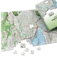
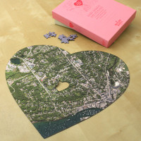
The Aerial Image Puzzle is a stunning, made-to-order 400 piece jigsaw puzzle featuring a highly detailed aerial image of any community in the USA, centered on an address of your choice. Using cutting-edge technology, high resolution aerial images have been digitally re-mastered to create a seamless "birds-eye view" of the entire United States of America. The image used for your puzzle is extracted from this gigantic master image. Please note that aerial images can range from between 2-5 years old and usually urban areas will be the more updated.
The 400-piece classic version is made from high quality 1.5mm millboard and the Satellite Puzzle will certainly draw upon your local knowledge as you assemble it. The completed, full-color jigsaw measures 18.5" x 12.25" and covers an area between 1 to 1.5 miles radius of your house which, of course, is at the center of the puzzle! You can also choose to get the National Geographic version!
The 300-piece handcrafted Premium Edition is made using wood that is 3mm thick, covers the same area around the address as the classic version above and also measures 18.5" x 12.25" when fully assembled. It also contains up to 15 whimsical pieces -- just for fun!
The classic version of the Satellite Puzzle arrives in an attractive box while the Premium Edition arrives in a beautiful "book box" within a luxurious velvet bag.
The Satellite Puzzle is a great housewarming gift, holiday present or birthday gift. It can also make a thoughtful "closing gift" for realtors to give to clients.

This item is custom produced upon order. Therefore, please allow 21 days for creation and then time for delivery. Note that we cannot accept returns for this item.Shipped by: 

-
Find Similar Products by Category